Institutional cooperation crucial for space-based disaster management, says JRC
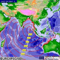
The Asian tsunami of 26 December 2004 produced an unprecedented response from satellite monitoring agencies around the globe keen to support the relief effort, and in doing so, highlighted the benefits of space technology for disaster management as well as its limitations. At a briefing on 'the forces of nature' during Earth and Space Week in Brussels on 15 February, representatives from a number of the agencies involved in the tsunami relief effort gave their perspectives on the state-of-the-art and future developments in Earth observation for disaster mitigation. Delilah Al Khudhairy from the Commission's Joint Research Centre (JRC) gave a detailed overview of the role that Earth observation played in the response to the tsunami, both immediately after the event and in the longer-term reconstruction effort. She first highlighted the importance of the 'international charter on space and major disasters', which allows agencies from around the world to coordinate their actions and share data in response to such emergencies, as well as the GMES partnership funded by the European Space Agency (ESA). However, during the first 36 hours or so after the disaster, explained Ms Khudhairy, the JRC and other international agencies had to rely on the world's media for crucial information, such as the number of countries affected and the type and scale of the damage. 'As this information came through, we began to programming satellites to try and focus on the affected regions and get the highest possible resolution,' she said. It quickly became apparent, however, that the tsunami disaster was of an unprecedented magnitude. In all, ten countries were affected, begging the question 'where do we point the satellites?' To try and focus in on the worst hit areas, the JRC first gathered all the freely available data it could, including population density maps from the US. This data was then overlaid with whatever wave effect data was already available to give the first rough idea of the scale of the disaster and the potentially worst affected areas. In the 72 hours following the tsunami, the time-consuming job of programming satellites to produce higher-resolution images of those regions caught up in the disaster began to deliver results. The JRC and its international partners were able to collect vegetation coverage data of urban areas, seafront and beaches, and by comparing it with images taken before the waves hit, were able to see where land coverage had been most dramatically altered - an indication of where the worst of the damage would be found. This data was then used to focus even finer resolution satellite imagery - down to 62 centimetres - on the worst hit areas. Given the ultra high resolution of such data, and the huge expense required to capture it, it was vital for the scientists to know exactly where they should collect these images in order to offer the greatest benefits to emergency teams on the ground. Despite the fact that the immediate relief effort is now over, Earth observation data is still being used to provide support to sustainable reconstruction in the countries affected. Archived data can help to reveal what infrastructure was in place and who owned it, and in combination with the latest satellite imagery, reconstruction teams can be guided to the most critical infrastructures lost in the tsunami, such as bridges and roads. As Ms Khudhairy points out: 'This experience tells us that we do now have the satellite technology to provide information and support for an effective humanitarian response, but what we clearly need is to improve the provision of that data in the first few hours after a disaster, as this is the most critical period.' Another conclusion that Ms Khudhairy drew related to the importance of institutional frameworks for cooperation in response to such disasters, such as the charter on space and major disasters. 'In one sense, we were lucky with the tsunami, as we had an existing archive of high-resolution pre-disaster imagery. What we really need is an institutional initiative to collect similar data for all potential crisis zones that can be used in the event of another disaster,' she added. Having proven the value of Earth observation technology in managing disasters, other speakers at the event made the point that satellites are only one element in effective disaster mitigation. Udo Gärtner from the German Weather Service said: 'A clear chain of activities is also needed, covering information gathering, analysis, impact assessments and, vitally, effective communications. Getting the information to people on the street when they need most it is a highly complex task.' Maryam Golnaraghi, chief of the World Meteorological Organization's disaster prevention and mitigation programme, highlighted the impact that effective 'end-to-end' disaster management systems are already having. 'Over the last three decades, the number of people affected by disasters has increased, the economic damage caused has increased, but the number of people killed has been reduced, thanks to effective disaster management strategies,' she said. Dr Golnaraghi emphasised the importance of translating improved operational capabilities into better products, services and decision making in response to major disasters. The role of national meteorological and hydrological services in this regard is crucial, she said, and called for a global initiative to improve these services. 'Simply look at the example of Haiti, where no such national system is in place, and the 3,000 lives that were lost in a single hurricane,' Dr Golnaraghi concluded.


