Reconstructing Persepolis
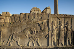
Persepolis is a Unesco World Heritage Site in Iran; the city was built by King Darius I (520–486 BC). As a result of modern-day human pressure and intensive cultivation, what landscape does remain of the Achaemenid period is disappearing over time. Remnants of ancient settlements are hard to locate. Thus, the only way do to so while still preserving the ancient remains is to embark on studies that combine archaeological survey methods. That was precisely the aim of the EU-funded 'Settlement and landscape organisation of the Persepolis region' (SELOPERSE) project, as well as to define the layout of what appears to be an uncommon loose and very open scheme of the ancient city. A joint Iranian–Italian expedition was formed to carry out the work. Intensive survey methods such as field walking and geophysical surveys as well as excavations in certain areas were used to prove the hypothesis on the ancient urban landscape. One of the main results was uncovering sections of a monument from the early Achaemenid period, which helped provide details on the city’s development. Farther our works allow us to suggest an extent of the Persepolis Royal Precinct thanks to the discovery of a new monumental complex. Furthermore, surveys on the foothills of the area revealed quarry remains. These provide evidence for outlining the limit between the city and its territory. Fieldwork also allowed for a way to test new methods for surveying landscaped areas by developing adaptations of field strategies using prototype instruments. For example, focusing on the magnetic properties of soil provides a way to trace ancient human activity. Researchers investigated many dozens of hectares via large-scale sampling. The maps obtained reveal a part of the mosaic of interwoven built and unbuilt areas that shape Persepolis city. With the project findings, new directions in research have emerged that can be useful for planning international programmes on the Achaemenid settlement system over the entire ancient Near East.
Keywords
Persepolis, landscape, Achaemenid, settlement, ancient city, archaeology, survey


