Protecting nature from space
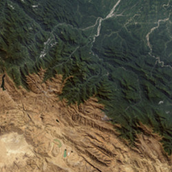
Ecosystems and the biodiversity they support are under growing threat from human activities and the negative environmental impacts they produce. These impacts may occur in the period between when an area is chosen to become a protected site and when it is actually made so. During this time these areas may be subject to forest fires, logging, mining, poaching or spillage of waste. The cumulative effect of such localised activities can lead to habitat loss and fragmentation. However, changes in the local environment can be detected remotely using EO technologies, thereby enabling authorities to take appropriate action. The aim of the 'Biodiversity multi-source monitoring system: From space to species' (BIO_SOS) project was to develop an ecological modelling system. The system will be used for monitoring NATURA 2000 sites and their surrounding areas, which are exposed to a range of pressures. NATURA 2000 is a network of nature protection networks within the EU. Named 'Earth observation data for habitat monitoring' (EODHAM), the proposed system complies with other EO and global monitoring initiatives. Researchers assessed study areas in three Mediterranean and two western European countries. Additional areas were considered in Brazil and India where the NATURA 2000 network does not exist. However, both countries would benefit from an advanced monitoring system for biodiversity protection. A key challenge was to develop a cost-effective system for monitoring changes in land cover within and along the borders of affected areas. Therefore, project partners used high spatial and hyper-spectral resolution EO data-understanding techniques to generate land cover and land change maps. Researchers also developed a modelling framework at both the habitat and landscape level to combine EO and in situ data for habitat maps. The maps were used for developing biodiversity indicators and for assessing and predicting the impact that human activities may have on biodiversity. BIO_SOS has resulted in advances in technical know-how and provided operational open source tools for site managers, researchers and policymakers. This has enabled them to implement adaptive management strategies and improve conservation of natural resources. The EODHAM system will also help reporting for the Convention of Biological Diversity (CBD), the European Biodiversity Strategy and the Habitat Directive.
Keywords
Earth observation, monitoring system, natural habitat, biodiversity, human activities, ecosystem, environmental impacts, habitat loss, ecological, NATURA 2000, nature protection, land cover, landscape, habitat map, natural resources


