New data service for ground movements
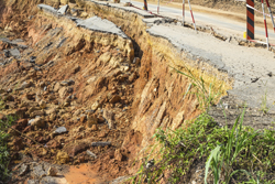
Across Europe, landslides and other ground deformations are a serious and underestimated problem. These can be natural or caused by human activities such as mining and construction work. The EU-funded 'Ground deformations risk scenarios: An advanced assessment service' (DORIS) project aimed to develop a data processing service to detect, map, monitor and forecast ground deformations in Europe. DORIS pioneered new data processing techniques in order to use Synthetic Aperture Radar (SAR) archive data from environmental monitoring satellites. This approach provided time series and maps of ground deformation in unprecedented detail. Project members also developed new techniques to analyse data from differential SAR interferometry — established ground deformation modelling software. These were coupled with ground-based sensor data to model and monitor rapid ground movements such as landslides. Case studies in several test sites around Europe provided real-life data to validate the new techniques. A spatial data infrastructure was built to allow for easy use of the new DORIS tools. Researchers completed a business model and sustainability strategy for DORIS to ensure that it will be able to function successfully as an independent service. The project has provided a sensitive and robust service for downstream users such as civil authorities and emergency rescue groups.
Keywords
Ground deformation, satellite data, landslide, ground subsidence, data infrastructure


