Molecular markers in dark bush crickets
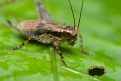
Agricultural landscapes cover more than half the surface area of the EU. However, the level of knowledge regarding their biodiversity has been relatively limited until recently. An EU-funded project, GREENVEINS, investigated the relationship between the structure of the European landscape, the intensity of use of agricultural land, and biodiversity. It was already known that biodiversity declines when land use intensity is increased and there is a loss of semi-natural elements such as hedges, woodlands and ponds. The results from this study were used to determine the vulnerability of biodiversity in agricultural landscape. The GREENVEINS project collected information on plants, songbirds and insects from 26 Landscape test sites (LTS) in seven countries in north western Europe. Researchers investigated metapopulations of nine indicator species, including P. griseoaptera. A metapopulation comprises populations of the same species spatially separated over the landscape. Using metapopulations the scientists could therefore study how such populations are affected by changes in landscape and land use. The results also revealed how biodiversity can become vulnerable, and these findings could be used to develop policies that support sustainable biodiversity in agricultural systems. Data on metapopulations was obtained through use of the capture-recapture technique and through the employment of genetic analysis. Population geneticists studied P. griseoaptera in order to identify novel microsatellite markers. These are repetitive stretches of short sequences of DNA which can be used for tracking the inheritance of genes. The scientists employed 12 microsatellite loci, which contained as many as 37 alleles per locus. These molecular markers can be used to investigate how landscape structure and land use intensity can affect genetic diversity in P. griseoaptera. The molecular markers were used to monitor cricket populations in two landscape study sites in Switzerland and Belgium. By investigating the relationship between indicator species and landscape structure and land use intensity the GREENVEINS project can develop tools for assessing biodiversity in agricultural systems. These tools can contribute to the monitoring of biodiversity in the EU and help in policy development and spatial planning.


