

New EU-funded project to save lives following disasters
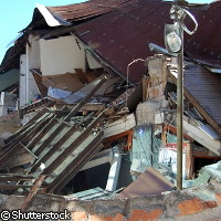
A new EU-funded project is developing a system that will save lives and mitigate damage to property and the environment in the aftermath of disasters. The two-year project is called GEO-PICTURES ('GMES [Global Monitoring for Environment and Security] and Earth observation with position-based image and sensor communications technology for universal rescue, emergency and surveillance management'), and EUR 2.4 million of its EUR 3.2 million budget comes from the Space Theme of the Seventh Framework Programme (FP7). When disaster strikes, relief organisations need rapid access to accurate and detailed information from the field in order to plan their response. GEO-PICTURES will use satellite communications technology to provide near-real-time access to pictures, videos, sensor data and other information worldwide. All information will be location-tagged, and experts in rapid online mapping will draw on a combination of GMES, and visual and sensor information to create real-time situational maps. The system, which will be hosted by the United Nations (UN), represents an important contribution to the management of large- and medium-scale emergencies around the globe. An early version of the system contributed to disaster-management efforts following the recent earthquake in Haiti. Under the GEO-PICTURES system, accurate field observations, such as photos, videos and audio recordings as well as data from sensors regarding temperature, moisture and wind, will be transferred to a control centre via satellite-optimised protocols. As well as contributing to disaster management efforts, this data will help improve the interpretation of space-based remote sensing data. In addition, the team plans to develop small, lightweight equipment based on the latest mobile technology. This will give disaster-management experts the opportunity to comment directly on pictures and communicate their needs to the Operation Centre. A location-based content distribution system will enable the transfer of large image files and GMES data over satellite channels. Furthermore, the researchers hope to investigate the use of small Unmanned Aerial Vehicles (UAVs) in carrying out observations. The project coordinator is Dr Harald Skinnemoen, founder and Managing Director of the Norwegian company Ansur Technologies. 'This is a very proud moment for Ansur and our long and sustainable efforts in developing our technology,' he said. 'We are happy that we have been entrusted by the EU to lead this project and for their confidence in our skills as project leaders and key technology developers in space-based satellite and wireless image communications for disaster and emergency response.' The project includes potential users of the system, experts in satellite communications, image compression, environmental research and providers of GMES services. Partners include the Amazonas state government in Brazil, the Universitat Autònoma de Barcelona in Spain, Johanniter-Unfall-Hilfe in Germany, the Assoção Brasileira de Telecomunicações in Brazil, State University of Amazonas (UEA), also in Brazil, the Swiss-based United Nations Institute for Training and Research (UNITAR) and Operational Satellite Applications Programme (UNOSAT), Disaster Management Advice & Training in Austria and Kongsberg Satellite Services (KSAT) in Norway.
Countries
Austria, Brazil, Switzerland, Germany, Norway