

Wilkins Ice Shelf disintegrates further
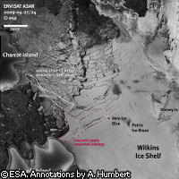
The northern edge of Antarctica's Wilkins Ice Shelf has started to break up, satellite images reveal. The new development was not unexpected; earlier this month, the slender ice bridge that anchored the ice shelf to Charcot and Latady islands finally collapsed. This event caused existing rifts along the northern ice front to widen and new cracks to form. Two German researchers, Dr Angelika Humbert of the University of Münster and Dr Matthias Braun of the University of Bonn, are tracking the fate of the ice shelf with the help of radar images from the European Space Agency's ENVISAT satellite and the German TerraSAR-X satellite. The ice bridge broke up on 6 April, and the rifts along the northern ice front were noticeably wider just three days later. The first icebergs broke away from the ice front on 20 April. The researchers predict that the northern edge of the ice shelf will continue to discharge icebergs over the coming weeks, and it is expected to lose between 570 and 3,370 square kilometres of ice. After that, they hope, a new, stable ice front will form, although it is not clear exactly how the situation will evolve. 'We are not sure if a new stable ice front will now form between Latady Island, Petrie Ice Rises and Dorsey Island,' said Dr Humbert. 'If the connection to Latady Island is lost, the projected loss of 3,370 sq km of ice might be greater - though we have no indication that this will happen in the near future.' A number of ice shelves have retreated and broken up over the past couple of decades. The Wilkins Ice Shelf lies south of South America along the western Antarctic Peninsula, a region which has experienced a temperature rise of 2.5°C over the past 50 years. The 13,000-square-kilometre ice shelf was stable for most of the 20th century, but began retreating in the 1990s. During 2008, it underwent a number of changes. In February 2008, over 400 square kilometres of ice broke away, with a further 160 square kilometres disintegrating in May. These events drastically reduced the width of the ice bridge; by May, it was just 900 metres across at its narrowest point. Yet more ice was lost in June and July, and in November massive rifts opened up to the east of Latady Island. In total, the ice shelf lost around 14% of its surface area over the last year. The ice bridge finally snapped at its narrowest point at the beginning of April this year. The detailed satellite images obtained from ENVISAT and other satellites are teaching scientists a lot about the way ice shelves break up. 'The changes to Wilkins Ice Shelf provide a fabulous natural laboratory that will allow us to understand how ice shelves respond to climate change and what the future will hold for the rest of Antarctica,' explained David Vaughan from the British Antarctic Survey. 'The quality and frequency of images acquired by ESA satellites mean that the break-up of Wilkins Ice Shelf can be analysed far more effectively than any previous event. For the first time, I think, we can really begin to see the processes that have brought about the demise of the ice shelf.' As it is already floating on the sea, the loss of the Wilkins ice shelf will not lead directly to a rise in sea levels. However, its demise is a strong indicator of the level of climate change experienced by the poles.
Countries
Antarctica