A positioning kit for visually-impaired smartphone owners
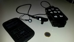
For people with visual or cognitive impairment, getting reliable information in an environment as hostile and frightening as a crowded city is vital. Navocap realised this in 2008, when it launched its subsidiary Angeo Technology. Since then, the company has received support from the likes of venture capital company Wiseed and CNES subsidiary Telespace Participation. It commercialised its Angeo-Mobile kit in 2012 to provide visually-impaired people with reliable positioning in dense urban areas. In 2015, it secured EU support under the ANGEO2 project, the objective being to improve the ANGEO kit and bring it to smartphones. Navocap’s main achievement was to overcome the limitations of GPS positioning with a technology of its own. ‘The low performance of other systems finds its source in the lack of reliability of GPS in urban environments,’ explains Edgard Antoine, CEO of Navocap. ‘In such environments, street canyons often block or divert satellite signals. Besides, the algorithms calculating itineraries rely on a modelling of streets based on their axis. In other words, if you stand, let’s say, on an avenue that’s 40 metres wide, the 5-metre precision you would usually get with a standard device requires you to wander in the middle of that avenue. I’ve tried it personally and wouldn’t recommend it to anyone…’ ANGEO2 – which was recently renamed ANGEO-S to better reflect its nature – comes in the form of a module that can be connected to any smartphone application requiring reliable positioning. The module comprises a reliable positioning unit (RPU), as well as a navigation app of its own, available on the App Store and called Angeo-NAV. Edgard Antoine explains how the system works: ‘The RPU connects to the smartphone via Bluetooth, and it can be attached to the user’s belt. A remote control pinned to the shirt collar allows for keeping the hand of the user free from any burden, and an earphone or bone conduction headphones can complete the kit in particularly noisy environments. The user can communicate with the device by using Apple’s “Voice Over” speech synthesis and recognition application dedicated to visually-impaired users.’ To resolve GPS-related issues, the device multiplies satellite-based information sources by using data from the world’s three biggest global navigation services: GPS, GALILEO and GLONASS. It then cross-checks this data with that of an inertial unit capable of determining the existence or non-existence of multiple pathways, and compensates for any loss of satellite signal. ‘When it comes to calculating itineraries, ANGEO-S uses a specific algorithm that takes into account street width, the need for multimodal routes (pedestrian, bus, tram, metro, etc.) and the personal preferences of visually-impaired people wanting to avoid major roads,’ says Edgard Antoine. Navocap plans for tests to take place at the Vision Institute in Paris at the end of September 2017. If all goes according to plan, Antoine expects a commercial launch in June 2018. In the meantime, the first-generation of the ANGEO kit including GPS receiver, inertial unit and cellular modem can already be purchased. ‘We foresee two main vehicles for commercialisation: associations working with blind and visually-impaired people, and door-to-door sales following a business model similar to that of companies like Tupperware,’ says Antoine. ‘ANGEO-S is a major step towards answering the needs of these users, and we couldn’t have gotten that far without support from the SME-Instrument,’ he adds.
Keywords
ANNGEO-2, ANGEO, ANGEO-S, positioning, navigation, urban areas, blind, visually-impaired, Navocap, GPS, Galileo, algorithm, smartphone, app, RPU


