Preserving Europe's underwater cultural treasures
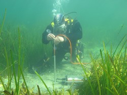
The goal of the EU-funded project SASMAP (Development of tools and techniques to survey, assess, stabilise, monitor and preserve underwater archaeological sites) was to develop tools and technologies for locating and mapping underwater archaeological sites and their preservation potential. The consortium included small and medium-sized enterprises experienced in developing marine geophysical instruments, biogeochemical measuring equipment and hand-held diving tools. New tools and technologies developed by project partners target improved excavation and raising of fragile organic materials when they cannot be preserved in situ and in monitoring and stabilising sites. Tools used by the consortium ranged from satellite scanning of potential sites to detailed multi-beam and shallow seismic surveying of identified targets. Data from these non-destructive studies was applied to a geographical information system (GIS) in order to locate archaeological sites and areas threatened by natural seabed erosion. Biogeochemical parameters in coastal marine sediments were monitored by developing marine data logging equipment. The team used measurements related to the degradation of organic archaeological materials in the marine environment to assess the preservation potential of sediments. Diver-held tools for sampling sediment cores from archaeological sites were also developed, as were tools for assessing the preservation status of waterlogged archaeological wood. In addition, project partners created innovative techniques for raising complex and heavily degraded waterlogged organic artefacts. Artificial sea grass mats were developed to stabilise sites in situ, and trialled in Denmark, Italy and the Netherlands. Researchers monitored their efficiency and the effect of the marine environment on the plastics contained in the mats. Findings have been published in two guideline manuals, available on the project website. The first explains the process of archaeological research in light of development-led archaeology and is aimed at policymakers, practitioners and people who work with cultural resource management who are not necessarily archaeologists. The second outlines the general methods available for locating, surveying, assessing, monitoring and preserving underwater archaeological sites, with particular reference to the new methods developed within the project. SASMAP will benefit the management of underwater cultural heritage in Europe and the rest of the world. Its valuable tools can be used for planning the preservation of underwater archaeological sites and their contents. This will enable counties to comply with the European Treaty of Valleta (1992) and UNESCO's Convention on the Protection of the Underwater Cultural Heritage (2001).
Keywords
Cultural heritage, SASMAP, underwater archaeological sites, remote sensing, in situ preservation, excavation


