Combating deforestation from space
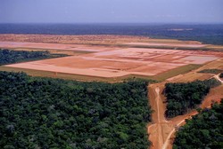
The aim of the REDD-FLAME (REDD fast logging assessment and monitoring environment) project was to design and test a system for monitoring in tropical and sub-tropical forests with the aid of very-high-resolution Earth Observation satellites. The system could be integrated into national or regional forest monitoring centres, providing inputs for large scale carbon emission assessment in the context of the UN’s REDD (Reducing emissions from deforestation and forest degradation) programme. The system complements existing low- to middle-resolution systems that cover entire countries or regions, monitoring areas at high risk of deforestation. By focusing on early detection of logging activities it will provide the means to quickly identify the first signs of deforestation thereby acting as a tool for controlling resource use and sustainable development within these fragile and immensely valuable environments. REDD-FLAME was designed to primarily use synthetic aperture radar (SAR) data, but a parallel approach employing optical remote sensing data was also implemented. Researchers identified a wide range of users, including indigenous peoples, forest managers, enforcement agencies, policymakers, and logging and mining enterprises, whose needs are addressed by a service concept that offers options for tailored operational implementation. High-resolution SAR data are used to create highly detailed maps of forest change to identify hotspots and detect indicators of illegal activity, such as camps and new roads. The resulting change maps improve knowledge of forest disturbances, enabling them to be located on the ground, and also provide information about the age of changes. These can be matched with intelligence or circumstantial evidence acquired in cooperation with local partners. Researchers implemented pre-operational systems in three countries – Brazil, Indonesia and Mozambique – to determine REDD-FLAME’s potential as part of a forest monitoring centre. The capacity of results to inform policymakers, provide information for monitoring programmes, provide evidence for law enforcement efforts and help local communities to protect their lands from illegal encroachment was demonstrated at workshops in each country. REDD-FLAME will help build capacity in the host countries for managing forest resources and combating deforestation, thereby conserving biodiversity and the natural environment.
Keywords
Deforestation, REDD-FLAME, Earth Observation, logging, synthetic aperture radar, mapping, land cover


