

Finding fossils from the air before setting out from the lab
Researchers in palaeontology currently have no way to predict where to look for fossils with some acceptable likelihood of success. They can spend considerable time and effort planning surveys yet return to the lab empty-handed or with poor-quality remains. With the support of the Marie Skłodowska-Curie Actions (MSCA) programme, MSCA Fellow Elena Ghezzo of the Ca’ Foscari University of Venice has developed signal processing tools for powerful multispectral imaging to make palaeontologists’ lives easier and their excavations more often successful.
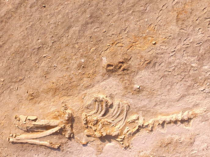
Finding fossils on the ground from the skies
Multispectral cameras rely on multiple sensors, each detecting different wavelengths. Images are created by overlaying image layers at each wavelength for each pixel, providing high-resolution, multi-material information. The cameras can be mounted on a satellite, drone or aeroplane and are already used for applications including environmental monitoring and military surveillance. Ghezzo explains: “The idea of finding fossils with multispectral imaging via satellites came to me like a bolt of lightning as I came out of a seminar at Ca’ Foscari presenting the MSCA programme. I knew the problem and the potential, I knew many places to test the method, and I had been introduced to multispectral imaging during my master’s studies. I needed to improve my knowledge of geology and remote sensing and my computer and statistical skills. The MSCA fellowship gave me the opportunity.”
Flexible, standardised multispectral imaging for fossil materials
With the fellowship, Ghezzo flew her drone over the Atacama Desert in Peru and exposed skeletons of extinct whales. She learned how National Parks in the United States work and how they preserve their cultural heritage for future generations, and she studied data on extant species at the National Museum of Scotland in Edinburgh. She then developed the tools that can, for the first time, analyse multispectral images and classify them with fossils as the focus. Ghezzo’s overarching goal was to standardise palaeontological studies to enhance comparisons. The repeatability and reliability of the methodology and data surpassed her expectations. “Multispectral imaging is a pioneering method for studies related to fossil materials. It can be used in the field as well as in labs and museums and for any kind of fossil material. My tools will help scientists identify not only promising excavation sites but also single fossil materials – a single fossil leaf or sauropod femur partially hidden beneath the surface – before leaving the lab,” Ghezzo explains. Their robustness will also pave the way to expanding the tool’s application to multiple fields.
The future of palaeontology
Multispectral cameras on satellites in orbit today record fewer than 10 wavelength bands (having fewer than 10 sensors) with sufficient resolution for the scope of this research (about 1-2 m). Hyperspectral cameras with more than 100 sensors are commercially available, although not yet flying on satellites. Resolution could improve to about 30 cm if the entire electromagnetic spectrum is included. Learning more about fossil spectral response in preparation for this tremendous increase in available data could be in Ghezzo’s future. She is revolutionising palaeontology and invites any reader wishing to apply her methods or collaborate to contact her.
Keywords
REFIND, fossil, multispectral imaging, palaeontology, satellite, drone, sensors, remote sensing