

Revealing Bronze Age traffic along roads in Upper Mesopotamia
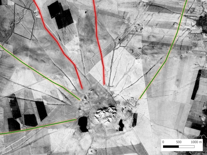
Perhaps because they are so ubiquitous and utilitarian, we take roads for granted, rarely appreciating the history literally under our feet. Yet roads tell us a lot about how past and present societies operate, connect, grow and contract. Ancient roads reflect the social, economic, political and religious relations of past societies. The EU-supported Marie Skłodowska-Curie Actions (MSCA) project GeoMOP investigated Bronze Age roads in Upper Mesopotamia, corresponding to north-western Iraq, north-eastern Syria and south-eastern Turkey, to develop a dynamic typology. After recognising modern vegetation as proxy indicators of ancient roads, GeoMOP used remote sensing analysis and agent-based modelling, to explore the formation and use of these roads. “By identifying roads which might have carried higher volumes of traffic than others, we transformed previously static road networks into dynamic maps,” explains Tuna Kalaycı, MSCA Fellow, based at the National Research Council in Italy.
Combining satellite imagery with modelling
The constant movement of people and animals over hundreds of years along these dry Upper Mesopotamian paths compacted the soil relative to the land around it. This movement ‘hollows’ out the road, making it much lower than the land on either side. GeoMOP relied on high-resolution images taken by the CORONA spy satellite during the 1960s and early 1970s, before more recent land changes, to observe these patterns of movement. The team also used satellite data, including optical multispectral and synthetic aperture radar imagery, to detect proxy indicators linked to changes in vegetation growth and moisture content. Again, this approach helped the team identify areas more compacted than others, indicating more use and so suggesting the presence of ancient roads. Finally, GeoMOP also built some agent-based models (ABM) to explore the formation of these roads. By running preprogrammed virtual ‘agents’, representing sheep and cows for example, on dedicated paths, they observed how the roads were likely to have been formed over time. “The real power of ABM came when we integrated environmental variables, such as precipitation levels. We could see clearly how these roads had also acted as drainage channels,” says Kalaycı.
A landscape in motion
Explaining the choice of location, project supervisor Nicola Masini observes: “Upper Mesopotamia is unique, as it has preserved clear patterns of movement, in rare detail. Here we have strong visual evidence of how ancient cities were connected.” This is important because the archaeological evidence shows that there was a ‘societal collapse’ due to rapid global aridification by the end of the Early Bronze Age around 2200 BCE. A similar collapse, but local to the Eastern Mediterranean, also occurred by the end of the Late Bronze Age (ca 13th-12th centuries BCE). Strengthening the Eastern Mesopotamia link between increased aridification and the collapse of cities could shed further light on other similar societal declines. Indeed, the team hope to apply their methodology to other ancient urban environments. GeoMOP has indicated how, with modifications to their method such as the addition of geophysics and urban traffic simulations, they can achieve this. For now, the team are focused on continuing to publish research articles and the proceedings of their conference, The Archaeologies of Roads.
Keywords
GeoMOP, Bronze Age, Upper Mesopotamia, aridification, Agent-Based Models, satellite, soil, vegetation, traffic, roads