A tiny aerial robot like no other exudes independence and thrives on adventure
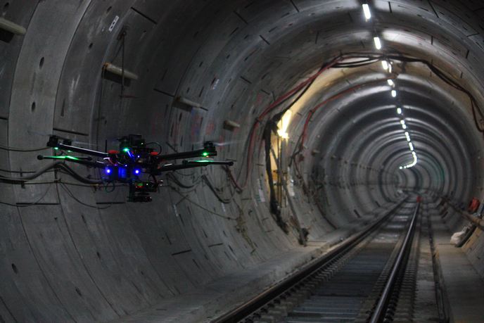
Drones have a long history, although their recent and explosive growth might suggest an overnight success story. Aside from military and consumer use, drone technology is now used in industries from agriculture and conservation to filmmaking and law enforcement. These drones in the sky rely on global navigation satellite systems (GNSS). The use of drones in underground areas or buildings without a GNSS signal is an entirely new field. The British/Spanish SME Hovering Solutions Ltd has developed the sophisticated technology required to propel this application into the mainstream. EU funding of the AutoFlyMap project has helped pave the way to commercialisation.
Flying into the future
Project coordinator and CEO and founder of Hovering Solutions Fran Espada explains: “Hovering Solutions has developed a revolutionary kind of flying robot (autonomous drone) able to estimate its position and navigate in underground areas, in the dark and in the absence of GNSS data. No pilot is required during the operation and radio communications can be lost without affecting the robot’s autonomous navigation capabilities.” It collects data as it flies, enabling high-resolution 3D reconstructions of the areas traversed. The AutoFlyMap drone has already been successfully used to reconstruct vertical ore passes in underground mines and tunnels for London Crossrail trains, among many other scenarios. In addition, field tests demonstrated a reduction in inspection costs associated with a hydropower plant to 35 % of those with conventional inspection methods.
Reducing risks while saving money and time
Before the AutoFlyMap solution, inspection of vertical shafts, tunnels, and galleries of mines and civil infrastructure required people using complex scaffolds, cranes and elevators that they transported and assembled. The AutoFlyMap flying robot significantly decreases associated risks, costs and time of survey and inspection while enhancing the amount of data acquired. Further, the simple, fast and effective solution facilitates more regular inspection of infrastructure, reducing risks related to potential failures, including human accidents or costly damage.
Expanding into uncharted territory
Espada founded Hovering Solutions in 2016 as its sole employee. He continues: “Since then, robot size has been decreased to 50 % of the original vehicles, and self-navigation capabilities have been enhanced significantly.” The company now counts 10 employees with legal entities in Spain and the United Kingdom and representatives in Canada, Chile and Norway. In 2019 alone, the number of employees in development doubled and the facility space tripled. The drone is being marketed as part of a product-as-a-service business model in which customers do not buy the drone but the value-added information it creates. Hovering Solutions adapts the output formats of the 3D models and other information to ensure compatibility with customers’ existing processes for analysis, reporting and assessment. Espada summarises: “The future is heading towards robotic integration and collaboration. The use of autonomous robots in risky underground environments will make the maintenance of infrastructures, the extraction of raw materials and the production of clean hydroelectricity easier, safer and more sustainable.”
Keywords
AutoFlyMap, drone, robot, underground, Hovering Solutions, navigation, autonomous, inspection, infrastructure, GNSS, mapping, mines