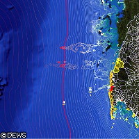
EU creates tsunami early warning system
EU-funded researchers have helped develop an early warning system that will protect vulnerable communities from tsunamis and avoid future terrible losses of life such as that suffered in Indonesia and Sri Lanka in December 2004, when an estimated 230,000 people were killed. EU support for the research came from the DEWS ('Distant early warning system') project, which received just over EUR 4 million from the 'Information society technologies' (IST) Thematic area of the EU's Sixth Framework Programme (FP6) to develop an advanced interoperable tsunami early warning system for strong early warning capacities. When a 1,600-kilometre (km) segment of the Indian tectonic plate jolted downward off the coast of Indonesia 6 years ago, it provoked the second strongest earthquake ever measured (a magnitude of 9.2) and tsunami waves 30 metres high. The resulting devastation brought home the urgent need for a system to give populations at risk from a tsunami as much warning as possible. Germany was the first to take action with a joint German-Indonesian tsunami detection and warning system (GITEWS). The EU decided to take this innovation further by funding and launching DEWS in 2007 to provide protection to all Indian Ocean nations. 'It's almost impossible to give numbers, but if DEWS had been in place in December 2004 a very large number of lives could have been saved,' said Andreas Küppers of the Helmholtz-Zentrum Potsdam, German Research Centre for Geosciences (GFZ), the researcher in charge of DEWS. The project is now being used to detect and analyse seismic events in the Indian Ocean, quickly assess their potential to unleash a tsunami, and warn at-risk countries through a network of detectors including broadband seismometers, land and ocean-surface based GPS instruments, tide gauges, and ocean bottom pressure control devices. The data generated by these instruments is streamed via communication satellites to a central station in Jakarta, Indonesia for processing. SeisComP3 software, developed by the GFZ, rapidly determines the magnitude and location of a seismic event. 'The former systems needed 11 or 12 minutes to detect a signal and locate the source,' said Professor Küppers. 'The same can now be done in four minutes.' Once the system detects an earthquake powerful enough to create a tsunami, it begins to analyse and model the risk of a tsunami. However, even with powerful computing capabilities, it would take too long to model a tsunami in real time. So DEWS researchers use libraries of temblors of different magnitudes and source locations, coupled with detailed simulations of the waves they would create along the Indian Ocean coastline, to determine which areas are at risk. In addition to this time challenge, the DEWS team has also had to cope with the difficulties of having to warn 20 countries in a multitude of languages, many of whom do not see eye-to-eye politically. 'It is a multilingual system that can distribute different messages to different people in different languages,' Professor Küppers pointed out. 'It was even more difficult politically to get all the players together at one table, but we are well on our way to overcoming those problems as well.' Researchers are now turning their attention to Europe and countries there at risk from tsunamis, namely those bordering the Mediterranean and the northeast Atlantic. They are even advocating the development of a new profession - that of the 'early warning engineer' - to offer maximum protection to vulnerable communities. 'If you want to tackle these problems properly, you have to take the time and effort to involve everybody,' said Professor Küppers. 'So we'd like to see people acquiring a new full-scale profession and be able to take care of the whole early warning field.'
Countries
Germany


