Earth observation provides business intelligence for smart farming
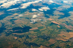
The EU-funded Horizon 2020 SME Instrument SAGRIS project supported the development of an affordable, problem-centric smart farming decision support back-end service. It is based on standard open source software components and open data from the Copernicus EO programme. The programme with its Sentinel-1 active radar-sensors provides a continuous time series of synthetic-aperture radar (SAR) images independent of cloud cover to create aggregated statistical data layers and dynamic composite images at different temporal scales to identify certain crop types and monitor their development during the farming season. For conditioning of certain crops, Sentinel-1 SAR images are calibrated with cloud-free Sentinel-2 multi-spectral instrument data. This helps deliver frequent, reliable and regular assessments of extreme soil wetness conditions and crop development in spring and summer, plus operational mapping, farming recommendations and assessment of damage or loss of crops. “SAGRIS is becoming a cloud-based imagery processing and Big Data analysis system designed to monitor millions of parcels of farmland, continuously providing end users with situational reports and early warning of any negative developments,” says Dr Gediminas Vaitkus, project coordinator and director of Lithuanian SME Geomatrix UAB. The power of processing chain SAGRIS exploits EO data for end-user applications by extracting and aggregating analytical information from raw satellite imagery. This is transformed into a back-end service providing per-parcel sampling data for various smart farming applications, as well as for applied research in agriculture, the environment, and economics. This EO data ‘processing-chain’ service – implemented as a collection of modular processing ‘blocks’ – has technologically independent but functionally interconnected components used for certain EO data pre-processing and added-value operations. These blocks can be employed separately on DIAS platforms or local clusters to perform certain automated processing operations or combined into automated work-flows to produce higher added-value information products. “We are currently working on analytical modules which use various geo-spatial and statistical analysis techniques – from simple clustering to complex machine learning,” explains Dr Vaitkus. SAGRIS blocks are used for image pre-processing, static and dynamic mapping and statistical data sampling. The ultimate goal of the process is reduction of EO data volume into compact, yet complex business intelligence databases ready for data mining and machine learning applications. “Parcel-based statistical sampling provides massive amounts of business intelligence data for various analytical applications and case studies. Even in a rather small country like Lithuania, SAGRIS can collect hundreds of millions per-parcel statistical measurements from a time series of Sentinel 1 and 2 sensors, providing an unprecedented sample of business intelligence data,” comments Dr Vaitkus. Benefits of smart farming The combination of radar and optical sensors reveals a complete picture of the farmland and crop status, enabling early warning of natural hazards, as well as efficient and accurate assessments of crop damage for insurance and subsidy claims. Information provided by SAGRIS can be directly used by the farmers for mitigating emerging threats, or reducing economic impacts caused by wild animals and unfavourable climate conditions. But – most importantly – it can disrupt the existing paradigm of EO information value for agriculture in general. Instead of web-based graphics and descriptions wasting precious time, leading to subjective assumptions, possible human errors and failures, SAGRIS offers a continuous flow of measurements and per-parcel satellite data samples for AI engines tracking and solving specific issues. On the other hand, Dr Vaitkus points out that SAGRIS also has an important socio-economic aspect. Smart farming services based on Copernicus open data should be affordable to small-scale farmers with no need for substantial investment initially. “We predict that smart farming services based on publicly available satellite data will ensure transparency in the EU’s Common Agricultural Policy processes, and encourage self-education, a progressive mindset and communication among small and medium-sized farmers,” he concludes.
Keywords
SAGRIS, data, farming, earth observation (EO), Copernicus